Skip to content

New Horizon Europe project ‘EvoLand’ sets off to develop new prototype services for the Copernicus Land Monitoring Service

Munich, January 24, 2023

A consortium under the lead of VITO officially launched the new Horizon Europe project EvoLand (Evolution of the Copernicus Land Service portfolioin Leuven (Belgium) on the 17th and 18th of January 2023. EvoLand will develop and test new and innovative methods and algorithms and implement a bundle of candidate Copernicus Land Monitoring Service prototypes. This will be realised by integrating novel EO and in-situ data with latest Machine Learning techniques to continuously monitor the status, dynamics and biomass of the land surfacefocussing on five key thematic domains – agriculture, forest, water, urban and general land cover.

GAF AG is part of this new research and development project that includes 10 key-players of the EU Space industry from 5 EU countries. The project will be running for the next 3 years.

Why EvoLand?

Since 2011, the Copernicus Land Monitoring Service (CLMS) provides core products for the monitoring of status and changes in vegetated and non-vegetated land cover/land use state and characteristics, biophysical variables, water and cryosphere conditions. Currently CLMS needs to advance in phase with the new Copernicus 2.0 programme, the evolving user needs, global challenges and technical capabilities, meanwhile maintaining the existing core Copernicus information products and services. This is a challenge which requires a more efficient workflow enabled by automation, harmonisation, further integration of the products across existing components (at local / pan-European/ Global level), modularity of the software and data products, and the increased use of Artificial Intelligence to provide real and near real time data processing.

EvoLand – Evolution of the Copernicus Land Service portfolio – addresses these needs in a comprehensive way through a well-designed process, developing innovative methods, algorithms and candidate CLMS prototypes to monitor the status and changes of land use/land cover and various land surface characteristics at high spatial and temporal resolution.

How is the project going to achieve its objective?

EvoLand aims to develop eleven next-generation CLMS product candidates by integrating innovative approaches in data fusion, Machine Learning, continuous monitoring and biomass mapping, as well as through the integration of novel EO and in-situ data. In addition, the project will analyse policy, data and infrastructure requirements for the prototype services, interact with the relevant Entrusted Entities (European Environment Agency [EEA], Joint Research Centre [JRC]) and consult other main Copernicus Land stakeholders and users.

Present at the kick-off meeting in Leuven on the 17th and 18th of January 2023, EEA and JRC representatives congratulated the consortium on this project and expressed their great interest in closely following the process and eagerly await the results, collaborating on the evolution of the CLMS.

During the demonstration phase of EvoLand, candidate services will be prototypically implemented over larger regions, focusing on key thematic domains such as agriculture, forest, water, urban and general land cover. They will be regularly analysed to ensure their fit for purpose, policy support potential, technical and innovative excellence, and operational readiness. The ambition of EvoLand is to support the Entrusted Entities by dedicated research, providing tangible proof of the evolution potential of the CLMS in terms of improved information content, quality and timeliness, and enable well-informed and facts-based decision-making on the future of the CLMS. A strategy to transferring these prototypes into operational CLMS services will therefore also be proposed as part of the project outputs.

The following eleven CLMS prototype candidates have been selected:

  • Forest: continuous forest monitoring, forest disturbance mapping, forest biomass mapping;
  • Agriculture: cover crop type mapping, cropland/grassland gross primary production monitoring, small landscape features mapping;
  • Water: improved water bodies mapping;
  • Urban: automated land use mapping of urban dynamics, continuous imperviousness monitoring;
  • General land cover: continuous mapping of land surface characteristics, on-demand land cover mapping.

The team behind EvoLand

EvoLand brings together a unique consortium of 10 partners from 5 European countries providing all the professional knowledge required for a successful achievement of the ambitious project goals and objectives. Led by VITO, an independent research organisation from Belgium, it involves also CESBIO (France), CLS (France), CNES (France), DLR (Germany), Evenflow (Belgium), GAF AG (Germany), IIASA (Austria), Joanneum Research (Austria) and Sinergise (Slovenia). In terms of expertise, the EvoLand consortium includes CLMS specialists, key CLMS service providers and leading research institutes in all methodological developments. The team also involves partners experienced in supporting the Copernicus in-situ component, driving innovative in-situ data collection, cloud infrastructure and mass data processing, as well as effectively engaging stakeholders.

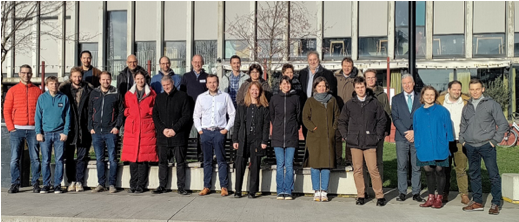
The team met for the first time at the kick-off meeting in Leuven with first discussions and decisions on the immediate steps, approach of certain tasks and further cooperation. “I am very proud of the competencies within the team and look forward to working closely together,” said the Scientific coordinator of the project Dr Ruben Van De Kerchove, VITO.

Image: Kick-off Meeting of EU Consortium of the new Horizon Europe project EvoLand (Evolution of the Copernicus Land Service portfolio) in Leuven, Belgium, on the 17th and 18th of January 2023

Credits: GAF AG

For further information:

Project PartnerGAF AG
email: copernicus@gaf.de Communication ManagerMr Asaf Covo, Evenflow
email: communications@evenflow.eu  
Project CoordinatorDr Ruben Van De Kerchove, VITO
email: ruben.vandekerchove@vito.be

About GAF AG

GAF was founded in Munich in 1985 as the first German company with a focus on applied remote sensing. It is now one of the leading commercial geoinformation service providers in Europe in the area of earth observation. As part of the e GEOS/ Telespazio group of companies, GAF offers an extensive service portfolio that, in addition to direct satellite data reception and distribution, includes advanced analysis techniques, AI processes and the tailor-made development of geoinformation and software systems, platforms and consulting solutions. The thematic areas of specialisation for public and private clients worldwide include land monitoring, natural resources management, water and environmental monitoring, agriculture and forestry, mining, emergency management and infrastructure security. GAF is also one of the most experienced European service providers in the EU/ESA Copernicus programme, with many years of service implementation for the Copernicus Land Monitoring Service, the Emergency Management Service, and the Security and In-Situ Service Components.

A number of further economic benefit studies were published over the last couple of months in 2022 within the Sentinels Benefits Study. Oil spill in the Mediterranean looks at how the CleanSeaNet (CSN) service operated by the European Maritime Safety Agency (EMSA) helps national authorities monitoring their waters.CSN uses Sentinel-1 and other data to identify potential oil slicks and possible polluters and, in a matter of minutes, transfer this information to the national competent authorities such as SASEMAR in Spain and Transport Malta. The increased risk of detection and successful prosecution is deterring ship’s captains from washing out their tanks and oil spills were reduced by up to 65% in the last 10 years.

Water Quality Management in Finland looks at how Sentinel-2 and Sentinel-3 data are being used to monitor water bodies in Finland. These measurements allow the environmental institute of Finland and regional environmental agencies, known as ELY Centres, to monitor the quality of water in lakes throughout their region to a degree that is not possible using traditional in-situ water sampling and testing. Using satellite data is especially helpful in a country like Finland where the large amount of water bodies would imply enormous associated costs for authorities should they have to use traditional monitoring methods across the whole country. Sentinel data therefore helps authorities to improve water quality at a lower cost, which in turn improves the quality of life for citizens, aids in the protection of biodiversity and helps to ensure environmental sustainability.

Next to these and other in-depth case studies, we published a visual summary report that provides a great overview of the learnings and conclusions we have been able to draw from our case studies so far. The report also gives a comprehensive picture of all the associated benefits derived from the use of Copernicus Sentinel data!

Besides our case analyses, we organised three sector workshops to engage with public sector stakeholders and to better understand the uptake of Sentinel data in these areas. The targeted sectors were road infrastructure management, forest management and water quality management. The workshop results can be accessed at our SEBS website!

More and more often we see satellite images on media around the world. This is because they offer a clear and honest vision of the Earth to understand and observe events such as climate change, drought, floods, temperatures, volcanic activity. 

Social media has accustomed us to sharing and re-sharing photos and videos, making some places suddenly famous because they are 'instagrammable', can be replicated form anyone with some “special filter” to make each picture unique. Earth Observation satellite images have become equally acceptable in recent years, but maintaining a natural 'objectivity'. 

MEEO developed the ADAM platform to facilitate accessing a large amount of geospatial environmental data. Besides traditional commercial land scientific applications, ADAM turned to be the optimal tool to speed up the creation of media contents: satellite images, pollution information, climate data and trends can be easily extracted, elaborated within the platform and distributed to the media.

From remote sensing expertise to communication, MEEO started the activity of ADAM in the social media world with a small internal team: from 2018 to now the satellite images have travelled from Twitter, Instagram, Facebook, LinkedIn and recently also Mastodon. 

(heatwave in India and Pakistan (April, 29th 2022)

As seen by Copernicus Sentinel3 LST (Land Surface Temperature). The tweet got more than 6 Millions of Impressions and 118 K of Engagements. This image was used by climate activists, political personalities and a lot of media all over the World (ex. The Washington Post).

From the web to the classic media (Newspaper and Television Broadcast) the step is short!

In 2020 MEEO started a collaboration with the Italian National Broadcast RAI: since then a lot of satellite images have entered in the Italian’s houses. With different communication guidelines, contents are created for the regular weather reporting (in close cooperation with the RAI Meteo team), but also to explain phenomena such as volcanic eruptions, extreme events, drought, climate change, coastal erosion. It’s great to see how many common people can understand and are able to interpret satellite images that until few years ago were only pertinent to the scientific community. The use of Adam's images in the children's section of the television program ‘Green Meteo’, broadcast on RaiGulp, was a great success.

This growing communication activity of MEEO is made up of constant comparison, research and study. Performance results of the social media accounts are rewarding, as well as seeing the use of the products by the scientific community and the approach and growing interest by the general public, also by the children. 

ADAM is the optimal link between the large amount of data generated every day by Copernicus, ESA and NASA, and the media community.

( 3D view of the La Palma volcano - Sentinel-2 image true color enhanced with short wave infrared channel, September 30th 2021)

UP42 has had an interesting journey since our founding in 2019, and 2022 was especially exciting. But before we dive into those updates, let’s start with a short introduction. UP42 is a platform and marketplace that provides API-first access to a wide range of geospatial data and analytics. We’re on a mission to simplify access to satellite imagery, expand the earth observation market, and make it easier than ever to access data and extract insights at scale. 

With this in mind, we launched the UP42 data platform, a one-stop-shop for all geospatial data needs, to overcome the challenges of ordering data from different providers. The UP42 catalog hosts archive data from providers such as Airbus, Capella Space, 21AT, Near Space Labs, and more. We’ve got optical, radar, and elevation data integrated into our platform. Here’s why this matters: 

● Instead of contacting or setting up accounts with a range of providers, which often means different compliance and maintenance needs, multiple contracts, and integrations, our users get one single interface (available via API, SDK, or console). Here, users can search for and order data, get price estimates and updates, and download their data, independent from data host capabilities. 

● Users can also activate automated status updates with webhooks, saving further time and effort. 

● The best part is: image previews are available for all products, and real-time requests in the catalog show which products are immediately available. 

It’s easy. Customers simply define order parameters (AOI, certain cloud coverage, start/end date) and integrate all the products they need. The same set of parameters

applies to all providers in an order, so adding a new product takes about 3 seconds: just enter the data product ID and the ID of the image needed for the order. This is especially important for projects that need a highly customized solution and a combination of different temporal, spectral, and spatial resolutions. Complete projects on time and within budget, further benefiting from an AOI-based pay-as-you-grow pricing model, with no volume commitments. 

And if a user can’t find the right archive data, they can task a satellite to capture the area needed. This gives the freedom to define exact parameters, collect the perfect image, and support informed decision-making. Last year, we introduced our streamlined tasking interface and brought all tasking actions together in one place. Whether placing a new tasking order or monitoring an existing request, the whole tasking process can now be managed within the platform. Below, we’ve broken down the tasking process into steps. 

● Place an order: choose a collection, draw an AOI, fill out the form, and submit ● View order status: view order AOI, status, and pending actions 

● Review feasibility: when the feasibility study is ready, review and choose from the options 

● Pay and activate: view and confirm the price to pay and activate the order ● Track progress and download your assets: when assets are ready, download directly from order details 

The UP42 tasking platform gives direct access to satellites from Airbus, Capella Space, ICEYE, and BlackSky, so users can benefit from different types of data and resolutions.

We’re always ready to process urgent requests. When dealing with budget constraints and a tight window, or simply needing to task satellites from different providers, UP42 can help. 

Acquired archive or tasked imagery can easily be processed externally, or even better: on our platform, where users can analyze data, enabling easy collaboration with team members. Data will be delivered to UP42’s cloud-based storage, where it’s available for further processing. Users can combine data from multiple providers, augment SAR with optical data and vise-versa, combine data with 3rd party analytics capabilities, or even bring their own data and algorithms. 
Data is also available for integration with other ecosystems, such as QGIS or Esri. Existing Esri users can immediately access UP42 storage and projects directly from their ArcGIS Pro account
And what does 2023 hold for us? Expect even more providers on our data and tasking platforms with Head Aerospace, Hexagon, and Satellogic, to name just a few. We’ll also be introducing an even better discovery experience on our catalog, along with multiple AOI support for tasking, STAC & one set of common geospatial metadata, processing capabilities for ARD, and much more.

Aspia Space, the leading satellite data intelligence provider, today announces two new appointments as it expands its team to meet growing demand for its pioneering Earth observation data intelligence service.

New Director of AI division

Co-founder and managing partner Mike Smith joins Aspia Space in a permanent role as Director of its AI division.  With a background in applying deep learning techniques to astrophysics, earth observation and medicine, Mike is a Fellow of the Royal Astronomical Society and a twice former recipient of The Alan Turing Institute’s Enrichment Scheme.

Mike co-developed the ground-breaking AI algorithm and deep generative learning code that removes cloud cover from our Earth observation imagery with Aspia Space’s founder and managing partner Professor Jim Geach while working together at the University of Hertfordshire.

Mike Smith commented: “I’m eager to keep Aspia Space at the cutting-edge of AI research, and very excited to begin working full time with such a talented group of people.”

New Director of Product

Sarah Fairbairn joins Aspia Space as Director of Product. Sarah recently completed her Masters in Data Science with Artificial Intelligence at the University of Exeter and picked up the Bright Future Student Knowledge Exchange Award for her outstanding project work. Prior to studying for her Masters, Sarah held the roles of R & D Director and Product Discovery Manager at LumiraDx Care Solutions, a medtech software company.

Sarah Fairbairn commented: “I am delighted to be joining the amazing team at Aspia Space.  Earth observation is such an exciting area, and I am looking forward to working with the team to expand Aspia Space's data intelligence offerings to create even more impactful and insightful products."

Commenting on the appointments, co-founder and managing partner Professor Jim Geach said: “Mike has already played a huge role in co-developing our ClearSky service and I’m excited to be working with Mike again as we continue to develop cutting-edge AI solutions for our clients.”

“Sarah’s experience in Product research and development and her passion for data science and finding simple solutions to complex challenges will be a huge asset to the business as we continue to scale over the coming months.”

About Aspia Space:

Founded in 2021 and based in Cornwall, UK, Aspia Space is a company pushing the limits of Earth Observation data. With over two decades of expertise in image and spectral analysis rooted in astrophysics, and bringing to bear cutting-edge deep learning techniques, Aspia Space is innovating in downstream Earth Observation analysis. We are passionate about deriving meaning from remote sensing data, unlocking value and gaining insights that others cannot. This allows our customers to make better decisions based on reliable intelligence, leading to improvements in efficiency, productivity and sustainability.

New Nigerian Online Mining Cadastre System based on GAF AG’s eMC+ officially launched

The Nigeria Mining Cadastre Office (MCO) in Abuja officially launched its new Online Mining Cadastre System, based on GAF’s eMC+ framework, in November 2022 at the 6th Nigeria Mining Week, in the presence of the Vice President, Prof Yemi Osinbajo, and the Director General MCO, Engr Simon Nkom.

The new system connects the six newly-established Zonal Offices with the headquarters in Abuja, and ensures efficient and transparent management of the mining sector in Nigeria. Investors are now provided with the possibility to submit applications and track the processing of these online, while the general public also benefits by getting access to cadastral information in real-time.


Munich, December 15, 2022


The GAF software eMC+ (electronic Mining Cadastre +) facilitates the administration and management of mineral titles by ensuring information transparency and accessibility. It forms the basis of GAF’s framework for providing mining cadastre authorities around the world with a complete package of consulting services and software tailored to the specific requirements of the cadastre domain. The system is designed to increase institutional capacities and efficiency by delivering a comprehensive mineral tenure management solution.

The new online system in Nigeria connects the six newly-established Zonal Offices in six geopolitical zones with the headquarters in Abuja, and ensures efficient and transparent management of the mining sector in Nigeria. Investors are now provided with the possibility to submit applications and track the processing of these online, while the general public also benefits by getting access to cadastral information in real-time.


The official opening of the new Mining Cadastre System eMC+ by President Muhammadu Buhari, who was represented by the Vice President, Prof Yemi Osinbajo, took place at the 6th Nigeria Mining Week in November 2022.

Vice President Yemi Osinbajo said: “Nigeria now has a cadastre system that is efficient, non-discretionary, transparent, and accessible to investors around the world. A number of strategic investments have been made in the development of digitised platforms and technology infrastructure to support digital systems for mining sector governance”.


The Director General MCO, Engr Simon Nkom, explained that the purpose of the online platform is to grant all existing investors and prospects from any part of the world access to their information online and in real-time, via laptops and phones. He further added that as a result of the new cadastre system upgrade, the country will be able to increase its revenue generation. He stated, “the system will encourage foreign investment in the sector. More people will be able to see that there is transparency, and Nigeria will benefit from these aspects in terms of greater revenue generation.


The upgraded cadastre system was implemented as part of “Mineral Sector Support for Economic Diversification Project - MINDIVER”, which was financed by a World Bank credit from the International Development Association (IDA). The contract for “Upgrading and Automatization of the Mining Cadastre Office for Online Applications, e-recording, Archiving and Establishment of Mining Cadastre Offices in the Six Geopolitical Zones” was signed by GAF in September 2018.


The project is a successful continuation of the long-standing relationship between the Nigeria Mining Cadastre Office and GAF, which goes back to 2007, when the first steps in realising a digital cadastre system were taken. The new system represents the latest development and provides state-of-the-art functionality via GAF’s eMC+.

More info about eMC+: http://emcplus.gaf.de/  and: https://nigeriaminingcadastre.gov.ng/emc


Image: GAF AG


About GAF AG – Germany


GAF AG is an e-GEOS (Telespazio/ASI) company located in Munich and Neustrelitz, Germany.  It is one of the leading commercial geoinformation service providers in Europe in the area of earth observation, with broad expertise in international consulting, development co-operation and programme management. GAF’s consulting services include institutional strengthening and capacity building, as well as the design, development, and implementation of customised geospatial information and software systems, advanced analytics techniques, and AI processes. These support government bodies, administrative departments and the private sector.  The thematic areas of specialisation provided for public and private clients worldwide are land monitoring, natural resource management, water and environmental monitoring, agriculture and forestry, mining, emergency management, and infrastructure security.  

GAF is currently conducting and has recently completed mining governance and consulting projects in, for example, Burkina Faso, Chad, Ghana, Sudan, Niger and Nigeria.

GEOSAT Team last summer

About us:

As a satellite operator and provider of EO products and services, we currently own and operate 2 missions: GEOSAT 1 (22m resolution) and GEOSAT 2 (up to 40m resolution at nadir) and we are also leading the development of our future constellation of High- Resolution & Very High-Resolution satellites, targeted at frequent revisit and increased resolution. Additionally, our alliances with expert partners' satellites (including optical & SAR sensors from medium to very-high resolution) allows us to offer an extensive portfolio, suited to multiple applications.

From 2006, our satellites have been delivering Earth Observation (EO) products and services to both SMEs and institutional customers such as the European Space Agency (ESA), European Maritime Safety Agency (EMSA), U.S. Department of Agriculture (USDA), Brazilian Airforce (BACE), GEOSYS and many others, and we currently provide IMINT-analysed products of conflict areas.

The combination of very-high resolution and very wide swath imagery (650km), complemented with analytics targeted at specific vertical markets in a great variety of fields and applications is one of our main assets. We supply tailored services, adapted to customer’s needs, and meet very strict deadlines (near-real time, within 30 minutes).

GEOSAT 1 & GEOSAT 2 have polar orbits

Our technical expertise includes:

  • 24/7/365 operations for real time services
  • Super Resolution enhanced pansharpened imagery at 40cm for detailed assessments and change detection
  • 1,6m scientific level enhanced resolution on each MS band (particularly for precision agriculture)
  • 650km wide coverages in one pass
  • High-frequency, multi- resolution monitoring and Federated Missions imagery (MR, HR and VHR)

How do we add value to our products & services?

We bring the potential of EO to people, businesses & institutions around the world. Our capabilities and experience, combined with our flexibility to adapt to customer needs, allow us to maximize value, helping to address global challenges from Space.

Thanks to our own satellites, together with our partners, we deliver high quality imagery and analytics for high impact insights which result in improved decision making.

The EO solution you need when you need it

10+ Years Archive. GEOSAT's extensive archive provides you the perfect dataset to monitor development over time in any area in the world, assess the field, detect changes and patterns, prevent, and anticipate certain situations or trends that are relevant to your business.

QRT | NRT Tasking & Delivery. GEOSAT offers you a 24/7 Tasking and Delivery Service providing tailor made solutions of any area of interest, anywhere in the world. Our customers can extract actionable intelligence for their business through a cloud-based application environment.

Change Detection. Our sensors feature a great capacity for multitemporal revisits in a very short period of time and provide high quality, multi-source, multi-resolution satellite imagery and daily multi-sensor mosaic.

Analysis Ready Data. Our experienced team validates the data quality and consistency and ensures the delivery of reliable analytics-ready imagery to you.

Analytics. By applying a range of algorithms to our imagery, we unlock information that can help you make better business decisions every day.

Support to Satellite Missions. All GEOSAT capabilities at your fingertips. 10+ years of experience operating satellites, processing images, and performing quality analysis.

Tailored EO Solutions. Our wide range of customizable products and services benefit customers and partners around the world, giving them reliable solutions that significantly accelerate decision-making in a great variety of fields and applications.

We offer you Value for Money:

We offer seamless access to data and workflows, without the need to build and operate costly platforms.

Contact us:

Follow us on social networks: LinkedIn Twitter Instagram

Email us at: media@geosat.space & sales@geosat.space

Or send us your inquiry via our web-based tool: https://geosat.space/

Michal Brichta is a co-founder of the newly-established Slovak Space Office and the head of its Industry Branch working under the Slovak Investment and Trade Development Agency (SARIO). In 2019 he initiated a new strategic approach to the comprehensive development of national space industry capabilities. Building on this approach, his team works today to support the further development of the Slovak space sector and its internationalisation with a focus on full utilisation of the country’s strong industrial and R&D potential as well as on the 21st century‘s newspace trends.

Context: Slovakia is not new to space. Already in seventies, our researchers and engineers were participating in international missions to develop space hardware. Since then, there has been a continued involvement of Slovak research and development in major international space missions such as Rosetta, Bepicolombo or JUICE. Today, the sector is still benefitting from these decades of experience which helps the emerging space industry. Currently, Slovakia counts more than 40 established companies actively involved in the space sector. Half of them focus on the upstream segment, but most of the space-related revenue is concentrated in software applications using Earth observation or navigation data. On top of that, there is a strong potential for future sector development coming from the industrial base as well, with key pillars of the Slovak economy including IT, electronics, high-precise machinery, or automotive.

Question 1- Could you introduce the Slovak Space office and the current Earth Observation (EO) landscape in Slovakia?

The Slovak Space Office consists of two components. The Ministry of Education, Science, Research and Sport of the Slovak Republic is responsible for inter-ministerial political coordination and multilateral international cooperation (European Space Agency, European Union, United Nations). Slovak Investment and Trade Development Agency – SARIO covers the implementation part of the agenda, especially developing the space ecosystem, local and international partnerships. We engage in a wide variety of activities ranging from sector-entry support, start-up creation and technology transfer activities, through international network creation, awareness building, and matchmaking, to local outreach activities focused at future generations of space professionals.

Downstream EO is currently the domain with the highest number of Slovak companies involved. More than a dozen of companies work on a wide variety of highly interesting and competitive solutions including infrastructure and land deformation monitoring, solar radiation monitoring, meteorological forecasting and modelling, forest disturbance mapping and monitoring, natural habitat monitoring, or early warning systems. 

Question 2- What are the objectives and the main priorities of SARIO?

Slovakia has recently become the newest associate member (AM) of ESA, which opens new possibilities for international cooperation. Over the past three years, our priority was to make our ecosystem ready for this transition and develop the necessary international network and support. Now with AM in force, our new priority will be to go through this transition as efficiently as possible.

In general, our main objective is to ensure that the Slovak space ecosystem systematically grows its capabilities and is considered a relevant and reliable international partner within the 21st century space economy and research. For that we have developed a three-point strategic approach consisting of maximising the utilisation of the space ecosystem’s full potential, diversifying the funding sources and markets to create a stable and resilient space ecosystem prepared for the opportunities and challenges of these days, and building a strong international position in the sector both in technological and non-technological areas.

Question 3- How do you envision the inclusion of EO for both public and private
users?

We find the overall topic of promoting and facilitating the use of space technology for terrestrial applications very important. Satellites provide us with large amounts of data that are easily accessible for researchers and companies transforming them into useful applications in a broad range of areas including transportation, finance, agriculture, energy and infrastructure or environmental protection, making them an important part of our everyday lives.

Downstream, and EO segment in particular, has grown into a strong part of the Slovak space economy and it also draws significant interest of young entrepreneurs and researchers as we could see during our CASSINI hackathon in November 2021 or the first batch of our newly-launched incubation programme.

Question 4-  How can EARSC support your activities and missions?

With EARSC we share an important part of our mission objectives. One of them is promoting the value of Earth observation and creating business and R&D opportunities in this dynamically growing domain. Another crucial one is promoting internationalisation of space collaboration. Here we do not only engage in activities focused on helping our companies and researchers to find new partners and get involved in international projects and value chains. Understanding the importance of democratisation of space for the benefit, resilience and efficient development of the European space sector as well as global space community, we also carry out our systematic undertaking aimed at supporting the development of emerging space ecosystems and bridging them with well-established players of the global space economy. Along with our flagship event Emerging Space, we have already brought this important topic to various major international platforms including UN COPUOS, IAC, or World Expo, and we are dedicated to continue in this endeavour. I truly look forward to further exploring all these synergies we have with EARSC and working on joint activities.

With the second phase of the programme having come to an end in December 2021, it’s worth a moment to reflect on the success the PARSEC Accelerator programme was able to achieve throughout its first and second phases, along with PARSEC’s lasting impact beyond these phases.

An innovation ecosystem fuelled by Earth Observation

PARSEC was designed to help small to medium enterprises (SMEs) and start-ups turn their ideas into commercial products and services onto the market by fuelling them with Earth Observation (EO) technologies, through an acceleration programme. More specifically, PARSEC focused on supporting these companies apply EO technology to address challenges in the emerging food, energy and environment sectors. These sectors are of high priority for society and were selected based on their increasing need to innovate in order to efficiently address the rise in food and energy consumption and the pressure on the environmental sustainability. 

Throughout the two stages, a total of 113 SMEs received support to create and improve new EO-fuelled services for the chosen sectors. This holistic support was organised around four pillars: access to knowledge, markets, technology and capital. Some of the resources compiling these four pillars are available to the public, such as PARSEC Business Catalysts or PARSEC Insights.

PARSEC’s lasting impact

Setting out to inspire innovation using EO technology, PARSEC has successfully enabled the creation of 15 impressive solutions that are now currently available on the market and/or ready to be scaled up to continue driving success. The sustained upward momentum of these solutions, in addition to the pioneering nature of the other solutions/services developed under of the umbrella of PARSEC, exemplify that EO-based innovation can revolutionize how food, energy and environment sectors operate to spur positive and lasting change that create value for society and the world. 

In addition, PARSEC demonstrates the direct impact EO can have on European entrepreneurship, as 31 out of the 100 companies selected for the first stage were newly created. Consortia applying for the Open Call 2 put forward 60 new EO-based solutions, and whilst 15 of these were selected for the second stage, several of the others continued to be developed independently outside the PARSEC Accelerator. Similarly, the PARSEC Business Catalysts will remain active and available to continue to support new and established EO-based services.

PARSEC video

The main success of the project – aside from the launch of 15 solutions and the successful support to 113 SMEs – was the creation and maintenance of the PARSEC ecosystem of SMEs, clusters, start-ups and other stakeholders. Furthermore, the PARSEC beneficiaries established strong cross-sectoral and cross-border partnerships, working together within PARSEC and other initiatives, fostering EO-based entrepreneurship. Overall, the successful and crucial work carried out over project’s lifetime have encouraged the consortium to continue supporting and participating in the PARSEC ecosystem and look into opportunities to build off the success of the project in the future.

Celebrating success

The project has paid special attention to the successful, strategic and sustainable dissemination of its final results: the development and commercialisation of 15 new EO-fuelled solutions. To this end, multiple actions have been carried out to promote and celebrate these solutions, notably, the organisation of a culmination event to present the project’s achievements and a Digital Showcase virtually presenting all 15 solutions and their developers.

Event picture

To mark the end of PARSEC’s second phase and to celebrate the success of the PARSEC community, a cullimination event – Launchpad to Success - was organised as a side event at Startup Valencia’s Digital Summit. The event consisted of PARSEC-dedicated events such as a pitching championship and face-to-face networking opportunities. In line with Digital Summit’s theme, Inspiring the good future, PARSEC also took to the Summit’s main stage to give a presentation on the generative power of EO technology to drive positive global impact, using PARSEC’s solution success stories as tangible examples. Learn more about the event here.

Showcase picture

Adapting to a more virtual environment, the PARSEC Digital Showcase was created with the members of #15PARSEC in mind. For each solution, a dedicated showcase page was crafted detailing the solution’s essential information. This promotional tool can be used by #15PARSEC to direct interested parties to an easy-to-use resource where they can quickly learn more about the solution, who’s created it and what they’ve already accomplished in their field. Explore the Digital Showcase for yourself here.

What’s next for PARSEC?

In understanding the magnitude of PARSEC’s lasting impact, the project team’s nine partners are continuing to examine options for the future of the accelerator beyond the end of the project. Specifically, the team is interested in continuing support for the development of EO-based products and services, and enabling access to finance, knowledge, markets and expertise. 

Are you interested in future partnership? Contact the PARSEC team today.

New to PARSEC? Check out this short summary:

The first PARSEC Open Call (Autumn-Winter 2019/2020) attracted 348 applications from 36 European countries. The 100 winners selected through the innovative peer-to-peer evaluation process became the so-called #100PARSEC. The 100 winners received €10.000 in equity-free funding and accessed the business support services of the first stage of the accelerator. 

With a major overarching objective being to promote the international competitiveness of European EO companies through cross-cluster collaboration, to apply for the Open Call 2 (Spring 2020), #100PARSEC teamed up, creating cross-border and/or cross-sectoral consortia of 2-4 SMEs. In total, the second call attracted 60 such consortia representing 142 SMEs (87 from within the accelerator and 55 “newcomers”) based in 32 countries. The winning 15 consortia or #15PARSEC were selected during the PARSEC Demo Days by a jury of experts consisting of industrial CEOs, investors and business leaders. These winning teams received access to funds (€100.000 per consortia) and to the second stage support services.

Visit the PARSEC website or check out a previous EO Mag article to learn more about the programme.