Category: Uncategorized
DHI Group: NEW CUTTING-EDGE EO TOOLS TO DELIVER SYNOPTIC INSIGHT ON “BLUE CARBON” ECOSYSTEMS
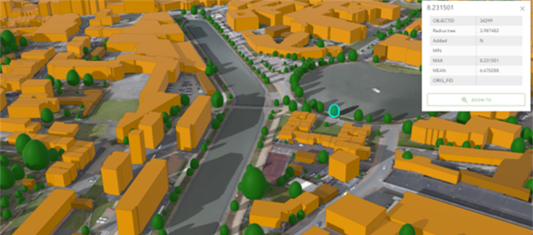
Eurosense: 3D tree map based on Artificial Intelligence and citizen science
Eurosense is proud to announce that our project proposal, together with VIVES University of Applied Sciences (Kortrijk, Belgium), to create a 3D tree map based on Artificial Intelligence and citizen science has been approved by Mrs. Hilde Crevits, Vice-Minister-President of the Government of Flanders. This project combines three areas of expertise of Eurosense: geodata, artificial intelligence and urban green. The objective is to identify individual trees and key attributes (such as coordinates, height, crown area, etc.), and to calculate carbon stock – starting from different sources of geodata. Via a web app, the tree cadaster will be accessible and can be enriched by citizens and experts. Don’t hesitate to contact Eurosense for more information about this innovative project.

New strategy to support skills development for the space and geoinformation sector
EO4GEO Alliance: The importance of skills development for Europe economic growth was stressed by the President of the European Commission Ursula von der Leyen’s State of the Union Address, setting 2023 as the year of skills. The EO4GEO Alliance set as follow-up of the EO4GEO project with the aim to continue the EO4GEO activities as part of the Sector Skills Strategy defined for the EO*GI sector and to enlarge the partnership to all key stakeholders for skills and workforce (including upskilling and re-skilling) development in the space geo-information sector as mean to support social and economic growth.
Editorial Winter 2022

Welcome to the first eoMAG of 2022!
Despite the still ongoing pandemic, the EO ecosystem continued its development during 2021 last quarter.
- From the institutional side, EUSPA finalized the signature of the agreements with the European Entrusted Entities and published last week its first report on the EO and GNSS market report (https://www.euspa.europa.eu); ESA launched three Accelerators: Space for a green future, Rapid and resilient crisis response and Protection of space assets.
- On the private side, companies such as Hydrosat, Satellogic and Planet raised significant capital, acquired other companies, and even the later went public with a $300 million war chest after SPAC deal. Additional capabilities entered in services such as Airbus Pléiades Neo 4 mid of December. Added values SMEs actors were also very dynamic, as illustrated by EOMAP creating a new office in Dubai.
2021 ended for EARSC with two key elements: the creation of a Working Group on the Green Deal with 25 companies involved and the closure of one of our project flagship PARSEC (https://parsec-accelerator.eu) at Valencia Digital Summit 2021. With the support of the European Commission, PARSEC distributed 2.5M€ equity-free to 100+ SMEs.
I wish you a happy and safe start to the year and hope to see you in person soon.
Interview with Yana Gevorgyan, the new GEO Secretariat Director
For the winter edition of eoMAG! 62 we decided to interview Yana Gevorgyan, the new GEO Secretariat Director. On July 1st, 2021, Yana was appointed as the new GEO Secretariat Director. In October Yana joined our EOcafe as a speaker, and we discussed the future of GEO, the involvement with the private sector and EARSC’s collaboration within the GEO community. We take this opportunity to continue the dialogue with GEO and, therefore, would like to expand more on these topics.
Yana, according to previous declarations, your vision for GEO includes strengthening GEO’s core membership participation in the organization’s mission, the connections with GEO’s regional structures and multisectoral partnerships. Could you please expand more on this?
GEO was established by countries (GEO members) to ultimately improve decision making for the benefit of the society and the environment through the use of Earth observations. To achieve this, we must make full use of countries’ institutional networks and our partners across the information value chain. From coordinating access to key data from a variety of sources, to analyses with the help of standards from which relevant insights can be extracted and packaged for specific user communities. This is the long journey towards attaining our goals. Readers know that while this seems like a linear mission, in reality this journey is complex, multifaceted and requires coordination on many levels, at different timescales, with different sensitivities.
GEO now has almost 120 members with many hundreds of national government agencies, as well as international organisations, non-governmental, civil society organisations, and the private sector. With such a large global community, we need to find different ways to ensure inclusiveness, as well as modes for engagement with all stakeholders. We know that many challenges today are global, but the actions and knowledge are mostly local. We use all available communication means and networks to increase our outreach to the national level. Regional GEO structures are invaluable in taking the global GEO vision and mission and programmatic activities and implementing them locally.
The GEO work programme is also essential to supporting the GEO community and as such, participation and contributions from GEO members are incredibly important. Increased participation of our members in GEO activities is fundamental to our continued development, i.e., knowledge sharing and impact. As we approach the third decade of GEO in 2025, an era that will be defined by our ability to inform accelerated actions to revert systems collapse and head off systemic risk, we want to take a more inclusive approach to problem solving. This means bringing together a broad range of experts, policymakers, and decision makers to focus on these challenges, rather than working alone in our areas of expertise. Multisectoral partnerships enable an integrative approach.
What are the plans for GEO for the new future? What is the vision for GEO in the long-term?
As just mentioned, we really want to focus on bringing communities together to share knowledge around global challenges and to amplify the voices of our members. The policy landscape is vast and complex but so are the data and tools that are increasingly at our disposal. What we really want is to have as much EO data and information freely and openly available with domain experts and local communities advising on how they can use it directly for decision making. We need official statistics and other data combined with Earth observations to provide as much insight and evidence as possible. Recently a mid-term evaluation was done for GEO, which provides us with direction for the immediate future. It is not a coincidence that there is much emphasis on the need to better and more effectively connect with national and local level stakeholders. In the longer term, it’s all about continuing to support our members with open knowledge.
How will GEO connect more with private stakeholders in the future?
As we bring more and more communities together, we need domain expertise, data, tools and services to help those communities make sense of all the information being produced. Our goal is to work more closely with small, medium, and micro-sized enterprises (SMMEs) to work at the national and local community level to understand needs and challenges, now and in the future. In this regard, the role of national actors is paramount as the private sector landscape differs from country to country, from region to region. Connections must be brokered, champions cultivated, relationships nurtured.
What tools will GEO use to create more opportunities for the small, medium and micro-sized companies?
Communication is one powerful tool in our arsenal. In my previous answer I mentioned relationships that need to be brokered and nurtured. GEO has created a level playing field for the private sector to partner through GEO. So from the process point of view, we are open to partnering. We have ongoing open calls for consultants or expertise for various activities under the GEO work programme and that will continue. In terms of a more systematic approach to engaging SMMEs, I think the work carried out by the team working on the GEO Industry Track, already in its third year, is important. As we sustain these efforts, we hope to see more SMMEs becoming aware of us as an engagement platform and a place to seed ideas that respond to known needs and demands.
How can EARSC support GEO’s activities and missions?
As one of GEO’s key partners for the private sector, EARSC has already been a great supporter of the GEO Industry Track, through the EO Café engagements and by generally working on programmes, such as eShape. As we look to expand our PPP activities and work with SMMEs in Europe and elsewhere, EARSC can help us understand the issues that matter most to your members and develop synergies with the rest of the GEO community. Through the Sentinel Benefits Studies, EARSC also has some great examples of the value of Earth observations that we can share with other regions of the world since we are all aiming for impact.
GEO can also continue to work with EO Evangelists. For example we have been collaborating with Irene Benito from Planet in her lead role for raw materials. In this context, we have been discussing possibilities to renew and strengthen our work on mineral resources in the GEO Work Programme. It would be interesting to connect with the other EO Evangelists for other similar discussions.
What would you like to add?
One important theme that occasionally receives an honorary mention but that deserves to be fully integrated into the culture and mission of any organization, including GEO, is inclusiveness. GEO has been working on increasing inclusiveness in terms of participation and representation. At GEO Week 2021, GEO adopted an Equality, Diversity, and Inclusion Statement, which will drive our efforts to promote inclusiveness through all the vectors of our work. At the same time, we created a GEO Youth Community of Practice, and we invite all young professionals, EO enthusiasts, young and aspiring entrepreneurs to join this network and create energy and power from within. We will also continue to support the underrepresented around the world, such as small island developing states and Indigenous communities, through ethical and inclusive means of engagement.
Thank you very much Yana for such a fruitful and interesting discussion! We are looking forward to more collaborations between GEO and EARSC!

Industry Profile – EOMAP
Tell us a bit more about your company
Marine coastlines, coral reefs, lakes or river catchments … - shallow waters are what we focus on. Since 2006, we have been mapping and monitoring aquatic environments for customers all over the world. Among these, we count renowned hydrographic offices, environmental agencies as well as industry partners. Our mission is to harness the terrabytes of satellite data recorded every day, offering our clients a quick, but panoptic view on shallow waters of their interest. This helps them deeply understand, manage and finally even mitigate impacts or changes. EOMAP is an Earth Observation expert for Satellite-Derived Bathymetry (SDB), Seafloor Classification and Water Quality Monitoring. In addition to high-tech data analytics, we provide IT-solutions, above all web-based software services. Last, but not least, we cooperate in manifold R & D projects, tackling artificial intelligence, green energy or drinking water. All in all, we strive to address both water related UN Sustainability Goals, SDG 6 and SDG 14.
What makes your services and products unique?
Basically, we combine three efforts to help understanding, managing and protecting shallow waters:
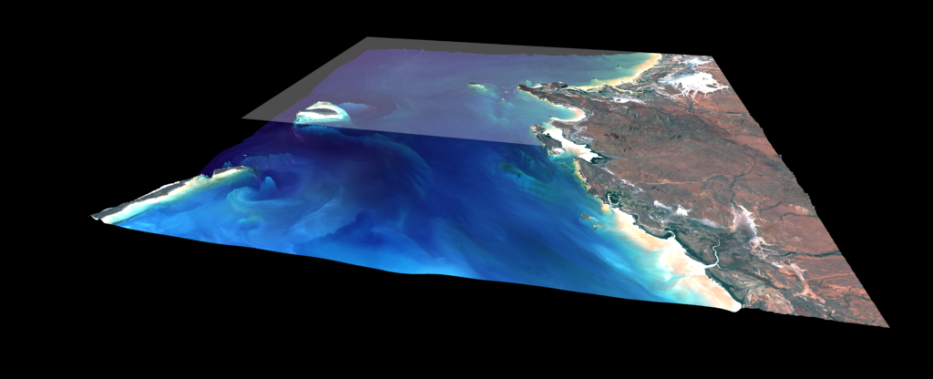
- Reduce environmental risks: Uncertainties in Earth observation can arise from various factors. The algorithms within our processing chain include mechanisms for quantifying these and flagging relative reliabilities. For the sake of accuracy, we base our work on standardised, physics-based and validated analytics. As technology leader, we were the first and sole company whose Satellite-Derived Bathymetry (SDB) was included in the British Admiralty charts. In another project we provided SDB for the world-first 3D habitat map of the entire Great Barrier Reef, comprising over 3,000 coral reefs.
- Face economic needs: Our customers wish to avoid risky, time or money consuming processes. They benefit from our long-term experience and 100+ projects per annum, involving water bodies around the globe. One of these was to monitor nearshore dredging activities in the Baltic Sea for Nord Stream 2, a gas pipeline. The coastal waters of Narva Bay are part of the Kurgalsky nature reserve, calling for careful environmental impact assessments and ecological surveys. Using a multi-sensor approach, we monitored turbidity and related suspended matter concentrations including seasonal changes.
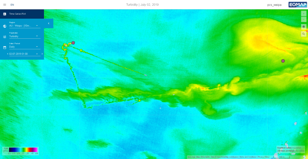
monitoring for a port authority – © EOMAP
- Support knowledge increase: We invite our partners to dive deeper into the values of remote sensing. Therefore, we offer more than consultancy and capacity building. By online and software solutions which we integrate into
their daily workflows, we empower clients to rapid and convenient data access. This can simplify their monitoring, reporting and planning. In this context, we have been providing high-res SDB data for the EMODNETconsortium
and - since 2021, for The Nippon Foundation-GEBCO Seabed 2030 – aiming at a freely available map of the world oceans‘ seafloor. As for the above mentioned monitoring project in Narva Bay, we offered a constant overview of water quality via our online platform eoApp.
What are your future plans for the company and your products?
We will certainly continue to turn satellite data into value – for our customers and the planet. In a nutshell: Evolving dashboards and more smart software solutions will keep us busy. At the HYDRO ’22 for example, we will launch the HYPOS suite, a toolbox for the hydropower industry, developed by a European consortium, supported by Horizon2020. Combining modelling with satellite data it offers direct access to key hydrological and water quality parameters and – finally – efficient sediment management. We are diving even deeper into the integration of multi-source data on aquatic environments, involving drones or unmanned maritime systems. And we are delving into topics highly relevant for the sustainable use of water, such as drinking water supply, plastic waste monitoring or blue energy.
Sounds exciting! Can we join you?
Sure. We’ve been growing constantly, and applications of broad-minded professionals are welcome. Above all, we appreciate people who can bridge the gap from environmental research to industry applications. EOMAP’s team unites physicists, software engineers, hydro-geologists as well as GIS and remote sensing specialists – of ten nationalities! Our HQ being in Castle Seefeld near Munich (Germany), we operate sales offices in Australia, the United Arab Emirates, Indonesia and the USA.
How can we contact you?
Please keep track with all our activities on LinkedIn, send an Email to we-care@eomap.com or arrange for a meeting via our web-tool on www.eomap.com.
Editorial Autumn 2021
Editorial by EARSC's Secretary General Emmanuel Pajot
Despite Covid, the EO Industry market continues its growth!
The publication of the EARSC Industry Survey is a milestone for the association. Initially published every other year, EARSC started in 2020 to publish a shorter survey in between. Based on numbers directly gathered from EO companies and monitoring of European EO companies performed by the Secretariat, the EARSC Industry Survey has a bottom-up approach. This year, the Industry Survey covers the 2020 pandemic period, a stressful period for companies. When we interviewed our members in March/April 2020, they shared they didn't have an accurate forecast on sales after six months-time. This Industry Survey provides a first snapshot of the short-term effect, which must be taken with caution not to extrapolate with a longer-term impact.
Four key numbers characterize the Industry Survey:
• The number of companies: the identification of new EO companies is a challenging exercise. The number of companies increased by 24% compared to the previous survey reaching 713. If some may not have been identified in 2019, this still represents the sector's overall growth.
• The number of employees: the EO downstream Industry represent a pool of 11,600 jobs, up from 9800 in 2019, i.e. a 17% growth for the two successive years. Amongst the changes, we see a higher contribution of initially non-EO companies such as GI ones incorporating now EO into their business services.
• The total revenues in the sector in 2020 is 1,71b€ representing a growth rate of 25% over the last 12 months. The most significant share comes from small companies, whereas the most extensive growth comes from medium-sized companies.
• The growth rate: the 5-year CAGR has been sustained at 10% since 2013.
In terms of markets, the domestic market share decreased a bit, illustrating the capabilities of European companies to sell services abroad. On the international market, the Middle East market presents the highest growth. An exciting message demonstrating the success of European companies to find new customers and develop user acceptance.
Further to the publication of this Industry Survey, we will now start the upcoming one. I would like to warmly thank the 150 companies that contributed to this achievement, sharing their numbers.
Interview with Rafal Modrzewski CEO at ICEYE
Tell us a bit more about your company
At ICEYE, we deliver unmatched persistent monitoring capabilities for any location on earth. We operate the world’s largest synthetic-aperture radar (SAR) satellite constellation, and we enable our clients to take objective, data-driven decisions, in sectors such as insurance, natural catastrophe response and recovery, security, maritime monitoring and finance. Traditional optical and radar satellites have been around for a long time, but the ability to image with the frequency, clarity and accuracy needed to make operational decisions has never been possible. ICEYE’s data and imagery can be collected anywhere on the globe, day or night, and even through cloud cover.
What makes your services and products unique?
ICEYE is enabling access to entirely new levels of data for the persistent monitoring of large and small areas across the globe – every few hours, day and night, in any weather. From tracking fast-moving objects like vessels in the sea to monitoring and addressing national security issues to potentially predicting natural disasters by identifying millimetre-level changes, ICEYE’s persistent monitoring unlocks previously unseen changes to the environment and human activity. Daily Coherent Ground Track Repeat (GTR) imaging is one of our key new services. It enables detection of everything from large changes, such as monitoring if ships have moved, all the way to detailed changes on-ground that a person on-site would not be able to recognize. The data enables performing Coherent Change Detection (CCD) every 24 hours, which has use cases in detailed monitoring of patterns of life, site activity, ground subsidence, infrastructure integrity, construction, and more. ICEYE now provides the world’s most frequent coherent radar satellite data coverage to a selected initial set of customers. The capability is delivered to customers as daily imagery delivered from individual customer-selected locations. This newly demonstrated capability is expected to be available for a wider customer base in 2022, after the initial early access period. Coherence is a term given for the exact similarity between two radar satellite images. If a car has driven across a field, stockpiles have been adjusted, or forested areas have been cut down, these are seen as changes in the coherence between the chosen two images taken from different times of that location.
What are your future plans for the company?
Natural catastrophe related services are a big part of our focus at ICEYE. So far in 2021, ICEYE has tracked more than 450 potential flood events globally, imaged over 350 potential flood events, and analysed over 30 flood events which each spanned a total area of at least 20,000 km 2 . In total, the company has launched 14 SAR satellites since 2018, with the most recent launch of four new spacecraft taking place in July. ICEYE also recently joined the seventh cohort of the Lloyd’s of London’s innovation accelerator programme, Lloyd’s Lab. Our collaboration with the European Space Agency has also been very successful and we expect it to take more steps forward, as the company has recently signed an agreement to serve as a Contributing Mission to the Copernicus programme, in addition to the Third-Party Mission agreement signed earlier this year.