
Tell us a bit more about your company
Our mission is to help both earth observation businesses and other markets to grow taking away complexity of imaging and providing easy, timely, and cost-effective access to satellite and airborne data. We enable this through our unique combination of best-in-class platform technology, extensive range of image sources, combined decades of years of Earth Observation market expertise, and independent and committed customer support. To date, we have provided imagery solutions to customers across 59 countries, and have implemented 20 R&D projects. Geocento was founded on December 1, 2011, so we will be celebrating our 10-year anniversary in a few weeks!
What makes your services and products unique?
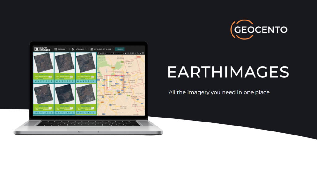
As a user of imagery, you should not have to identify and compare providers, navigate their complex range of products and services and commit money to one supplier before knowing that their data is the most suitable, or whether the data can be collected successfully. You should have a simple way of being able to select and access imagery without being some kind of earth observation expert with a detailed grasp of jargon, technical specifications and the latest order parameters! You should have a simple way of identifying what you want, ordering the most suitable product or service, and then receiving it, all through the same platform! That is why we have developed EarthImages – the industry platform of choice for discovery and ordering of imagery from a market-leading range of image suppliers. Currently, it provides access to data from 87 satellite sensors… or more than 230 if we include Planet’s fleet!
With EarthImages, you can access a broad range of imagery products from commercial ultra-high-resolution optical 15 cm HD, SAR, hyperspectral, night and video to non-commercial data sources (which we provide “for free”). This is unique – no other industry platform offers all this in one place! And it is not only about the vast sensor portfolio. EarthImages is a powerful application that allows you to manage and use your imagery in one place. For example, you can keep a track of your orders, configure and compare image plans, and share imaging campaigns across multiple users and organizations. Your project team can be involved in evaluating and selecting imagery. Online license signing, choice of payment methods and simplified delivery are standard. Furthermore, you can render your imagery directly and store it securely in the platform. There is no need to download and embed it into another application. If you create your own algorithms, you can host them on our platform and apply them to your data, avoiding the need to "take the imagery to the algorithm". To display results using our map client, you just need to copy and paste the URL – and you have them added to your environment. The full range of capabilities of EarthImages can also be integrated into your own operations using our convenient API tools, or can be customized as a white label web application.
It is worth adding that we provide consulting and support clients at each stage of their imagery journey: from clear definition of business needs to operations and staff straining. You can access the open version of EarthImages free of charge here. Please contact us if you require advanced tools and would like to discuss enterprise solutions.
What are your future plans for the company and your products?
Currently, we are working on an ambitious and very exciting service called EarthImages-on-Demand. This service is all about fresh collection of imagery that puts the customer in control, with competition between suppliers driving
standards for the benefit of the market. A user simply specifies what he or she wants, when and where. The request is then broadcast to all relevant suppliers in real time. All relevant suppliers receive the request and respond according to their imaging capacity. Money is committed but no payment is required unless and until the order is completed to full specification – we provide quality control. The whole collection process is managed using a shared image acquisition plan that enables suppliers to make informed decisions on collection while the user is kept informed of progress. As you can see, it is designed to be very easy and user-friendly! We would love to hear from early adopters who wish to benefit from using EarthImages-on-Demand before its commercial release. Please send us a request if you have a possible pilot project, or just wish to find out more. You can find more information here.
Sounds exciting! Can we join you?
Of course! We are looking for multi-disciplinary talents to join our team in
Oxford, Madrid or remotely. Do send us your CV and cover letter to recruit@geocento.com
How can we contact you?
We are always happy to get in touch! Choose the most preferable way for you. Drop us an email:
Kim Partington, CEO: kim.partington@geocento.com
Thomas Lefort, CTO: thomas.lefort@geocento.com
Maryia Urazaeva, Sales & Marketing Director: maryia.urazaeva@geocento.com
Call us: +44(0)7833136019 or meet us in our offices at Harwell Campus near Oxford and in Madrid, or at industry events. Visit our website, and submit online form: https://geocento.com/ Follow and reach us out on social networks:
LinkedIn: https://www.linkedin.com/company/geocento/
Twitter: https://twitter.com/geocento