Skip to content

Description

jeobrowser is a consultancy and software development SME specializing in geographical information systems and Earth Observation field. It was founded in 2010 by Jérôme Gasperi and it is based in Toulouse, France.

For years jeobrowser has been developing cutting edge applications in the EO domain. It’s open source EO catalog and semantic search engine (resto) is at the core of several projects including the French Sentinel Data Processing Center (PEPS), the THEIA Land Data Center and the CREODIAS catalog. On the client side, the rocket web application won the 2016 “European EO product of the year” award from EARSC.

jeobrowser is involved in the development of the 2016 Copernicus Masters ESA App Challenge winner – SnapPlanet. SnapPlanet offers citizens and storytellers a new medium to educate and communicate about the social, economic and environmental issues that we face today on a global in a more impactful and trustworthy way by providing a social mobile app to easily access, process and share Earth Observation imagery.

Applications

iTag

Semantic enhancement of Earth Observation data

iTag is a web service for the semantic enhancement of Earth Observation products, i.e. the tagging of products with additional information about the covered area, regarding for example geology, water bodies, land use, population, countries, administrative units or names of major settlements.

resto

REST search engine for geOspatialized data

resto is a metadata catalogue and a search engine dedicated to geospatialized data.

Originally, it’s main purpose it to handle Earth Observation satellite imagery but it can be used to store any kind of metadata localized in time and space. resto search API is compliant with the CEOS OpenSearch Best Practice Document and is mentioned in ESA’s « Exploitation Platform Common Core Components » as the closest implementation of a catalogue component according to the requirements specified in ESA's Exploitation Platform Open Architecture.

resto have been used in several projects including:

• CREODIAS

• Rocket - The Earth in your pocket

• The French Sentinel Data Processing center, PEPS

• The French Space Agency, THEIA land data center

• The Polish EO Data finder

• Remote Sensor Technology Center of Japan, EPIC project

• Sentinel Australia Regional Access

• Sinergise sentinel-hub OpenSearch API

• ESA's Food Security Thematic Exploitation Platform

• ESA's Forestry Thematic Exploitation Platform
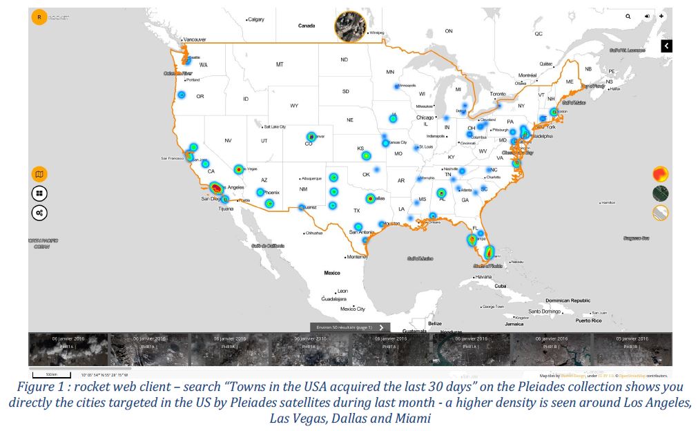
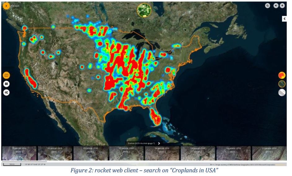
rocket

The Earth in your pocket

rocket is a Web application that provides a unique entry point to search, visualize and download Earth Observation products from various catalogs.
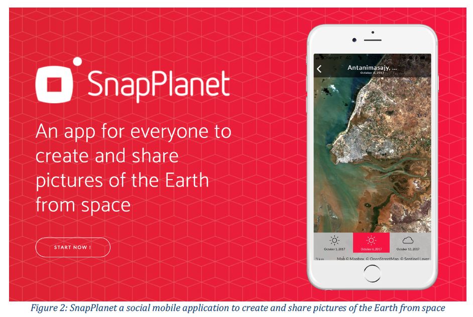
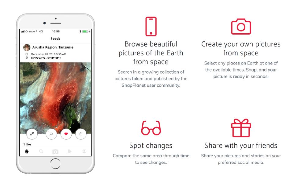
SnapPlanet
An app for everyone to create and share pictures of the Earth from Space
Download the app here.

« As the very first Earth observation social network, SnapPlanet brings EO data to the mass market in a fashionable and easy to use way. Amongst other benefits, the application provides its users the opportunity to explore, post, share and print the latest and best Sentinel-2 imagery. SnapPlanet combines the ever-increasing availability of Earth observation images with the advantages of a social network for everyone. »

Dr Thomas Beer
Copernicus Policy Coordinator
European Space Agency (ESA)

SnapPlanet is a social network with the aim to harness the use of Earth observation data to address individual, societal, environmental and economic needs through user- and community-oriented services. SnapPlanet is a mobile application in which users can choose a location around the world at a given time, “snap” it, and share the precise pictures of places taken from satellites with their followers. SnapPlanet provides this service for free, using Sentinel-2 imagery. The medium-term objective is to extend this service to include commercial sub metric imagery. Combined with high user demand and the increasing acquisition capabilities of satellites and drones, this will make selfies from space possible at the cost of a few euros. By providing citizens with access to EO images, SnapPlanet will be a catalyst of innovation and the creation of new EO databased services.

In April 2019 Wasat launched Jupyteo.com service: IDE environment, based on the popular Jupyter Notebooks technology, focused on processing of EO data in the cloud. Users gain access both to data sets and to functions useful for their processing, visualization and sharing. The main advantage that distinguishes this product from other tools is, apart from using ready-made algorithms, the ability to quickly and easily create users’ own algorithms or scripts. As a result, the data processing can be controlled strictly at every stage and in a formula adapted to any user needs. Although the basic programming language in Jupyteo is Python, it is possible to create code in other languages by launching additional engines offered by the integrated Jupyter Notebooks functionality. Jupyteo by default also offers the ability to create scripts in R, Scilab, Bash and indirectly - by launching the "magic cells" technology – it gives access to JavaScript programming capabilities.

Using the Jupyteo environment comes down to logging in to a Jupyteo account and automatically launching the web service. A user gains access to his own separate virtual environment based on Docker virtualization technology. There is a fully functional application at the user’s disposal along with the disk space for data storage. Work can be started by opening one of many provided scripts that are called notebooks in this system or by creating one’s own script from scratch. Regardless of the chosen programming language, an algorithm can be divided into parts called cells, each of which can be run separately. The created script source code contained in a single cell can be run online by issuing the "run cell" command or pressing the Ctrl-Enter combination. It is also possible to run all cells at once as the entire programme, depending on the user's preferences. The result of processing from each cell is visible directly below it and is presented in a text or graphic form, depending on what value is given as an output. The programme created this way can be saved as a script in a *.ipynb file, whose internal format is JSON. It will be saved to a user's account and can be launched at any time or downloaded to a home computer.

The map component is a feature that distinguishes Jupyteo and adapts it to the needs of community interested in processing EO data. The side panel on the right side of the screen is divided into tabs. One of them provides a map, which allows to search EO data and to automatically present the results of the processing. Its functionality has been taken from popular GIS systems. Thus, any result of the algorithm in a form of spatial data can be added to a map on an ongoing basis. These can be raster data formats like PNG, JPG, BMP, vector formats such as GeoJSON or services like TMS or WMS. A user has an option to create, launch and share his own WPS service that processes data and sends results to a specific location or to use the results of data processing services from other providers.

Another useful feature of Jupyteo is the ability to create code snippets that can be reused at any time after saving. A user can find a set of ready-made snippets in the "Snippets" tab on the side panel.

Jupyteo also provides the ability to search spatial data services by using functions placed in the side panel toolbar. After indicating the area and entering search parameters, a user will get a result in the form of ranges of found materials visualized as a graphic layer on the map. Each object representing the single range has attributes that allow to read metadata of the material and download or connect it to one’s own algorithm.

As already mentioned, a user of Jupyteo gets his own virtual environment, which gives the possibility of quite extensive interference and control over the installed software components. It is possible to switch to terminal view at any time, which gives direct access to the virtual system shell. One then can add or remove libraries on which Jupyteo is based and customize the system's functionality to suit user's needs. A user can also make other changes within the installed applications or additions of the system platform itself and configure it for strictly defined needs. Jupyteo has a built-in text editor through which a user can make changes to any file saved on his account. All files can be freely downloaded, placed on the server or shared with other users.

Jupyteo is intended for advanced users since, due to the programming-based approach, it offers immense opportunities to work with data, to process and modify it. Thanks to an access to the shell it is also highly flexible, allowing free configuration. Although it is an online tool placed in a virtual operating system and accessible via a web browser, working with it is similar to working with a desktop application.

If you want to use the service, please go to www.jupyteo.com and register using your Github account. As part of the Jupyteo offer, a user can get free trial access to a fully functional platform. In near future a paid version will be available allowing unlimited use of the Jupyteo environment.

TerraScan examines raw material deposits such as Lithium- and Kobalt for strategic analyses of offer and demand for the E-mobility Industry and next generation car battery developments. TerraScan applies its proprietary gScan Technology, a satellite pictures based analytic tool for global raw material sourcing. TerraScan's approach enables rapid, environmentally friendly and discrete exploration of new and existing deposits around the world without prior licensing in the context of geological exploration.

TerraScan could convince Volkswagen as one of the first industrial customers about its innovative technology. Volkswagen recognises the opportunity to localise quickly relevant raw material deposits such as Lithium and Kobald for e-mobility as a chance to secure its raw material demand in the long term.

The first exploration took place by processing very big territories down to 500 meters and beyond within a timeframe of only a few weeks. Details are not going to get disclosed.

The goal for Volkswagen is to secure the covering of its demand from sustainable sources at longterm projectable conditions. Volkswagen is therefore in close contact with all partners along its value chain. The analyses of barely tapped deposits is for Volkswagen an innovative addition to their current strategic activities.

"This project demonstrates our ability to provide investors and strategic decision makers with detailed knowledge, options and decision support for securing raw material sources quickly and early in the decision-making process, without having to undertake extensive on-site investigations." Jörg Enge, Managing Director and Founder, TerraScan GmbH.

TerraScan GmbH is a Berlin-based NewSpace service company that specializes in the efficient and sustainable discovery of mineral resources. The proprietary gScan process uses satellite images applying geological expertise, specially developed algorithms and artificial intelligence to identify all types of natural resources. It has been successfully applied to oil, gas, water, lithium, precious metals, and even water and geothermal energy sources. Detailed data is generated on location, depth, distribution and quantity both at sea and on land, even in the mountains. By nature, gScan is much faster and cheaper than conventional methods. In contrast to seismic, blast testing or drilling previously used, gScan is non-invasive, totally discreet and sustainable. It is also highly efficient to scan entire regions or countries for target resources.

There is a good overview on www.terra-scan.com including cases on https://terra-scan.de/projects

TerraScan/oh/ Berlin, Feb. 4. 2019

Rückfragen/ For questions please contact:

Oliver Haeggberg, Managing Director

oh@terra-scan.com

phone: +49-30-233 945 27 +49-170-45 42 586

TerraScan GmbH: Allee der Kosmonauten 32c, 12681 Berlin, (Germany) https://www.terra-scan.com

#

TerraScan GmbH, Presseartikel/Press Artikel 2019_1

ZUR SOFORTIGEN VERÖFFENTLICHUNG/ FOR IMMEDIATE RELEASE

Volkswagen nutzt Terra Scan zur Sicherung von Lithium und Kobalt

TerraScan untersucht Rohstoffvorkommen wie Lithium- und Kobalt für die strategische Angebots- und Nachfrage Analyse der E-Mobility Industrie für die Entwicklung der nächsten Generation von Autobatterien. Dafür nutzt TerraScan seine gScan Technologie zur Satellitenbilder gestützten Analyse weltweiter Rohstoff Beschaffung. TerraScan’s Ansatz ermöglicht die umweltfreundliche Untersuchung von neuen und bestehenden, globalen Lagerstätten ohne vorherige aufwendige Lizenzierungsprozesse im Rahmen einer geologischen Exploration.

Als einen der ersten Kunden konnte TerraScan Volkswagen von seiner innovativen Technologie überzeugen. Die Möglichkeit schnell relevante Rohstoffvorkommen wie Lithium und Kobalt für die E- Mobilität zu lokalisieren ist eine Chance für Volkswagen, seinen Rohstoffbedarf langfristig abzusichern.

Die erste Untersuchung erfolgte durch Verarbeitung sehr großer Territorien bis zu einer Tiefe von mehr als 500 Metern in einem Zeitfenster von wenigen Wochen. Details werden nicht veröffentlicht.

Volkswagens Ziel ist die sichere Deckung ihres Bedarfes aus nachhaltigen Quellen und zu langfristig planbaren Konditionen. Zu diesem Zweck steht Volkswagen im engen Austausch mit allen Partnern entlang ihrer Wertschöpfungsketten. Die Analyse bisher nicht erschlossener Vorkommen stellt für Volkswagen eine innovative Ergänzung ihrer aktuellen strategischen Aktivitäten dar.

„Dieses Projekt ist stellvertretend für unsere Fähigkeit, Investoren und strategischen Entscheidern Detailkenntnisse, Optionen und Entscheidungsgrundlagen für die Sicherung von Rohstoffquellen innerhalb nützlicher Frist und sehr früh in der Entscheidungsfindung zu beschaffen, ohne sogleich aufwendige Untersuchungen vor Ort durchführen zu müssen.“ Jörg Enge, Geschäftsführer und Gründer, TerraScan GmbH.

TerraScan GmbH ist ein Berliner New Space Dienstleistungs Unternehmen, das sich auf das effiziente und nachhaltige Auffinden von Bodenschätzen spezialisiert hat und verfügt über eine weltweit führende Technologie: Das proprietäre gScan-Verfahren identifiziert auf Grundlage von Satelliten- Bildern unter Verwendung von geologischem Fachwissen, speziell entwickelter Algorithmen und künstlicher Intelligenz Bodenschätze jeder Art. Es wurde bereits erfolgreich angewendet auf Öl, Gas, Wasser, Lithium, Edelmetalle uvm., sogar Wasser und Geo-Thermie. Es werden detaillierte Daten erzeugt über Ort, Tiefe, Verteilung und Menge sowohl auf See als auch auf Land, sogar im Gebirge. gScan ist naturgemäß sehr viel schneller und kostengünstiger als die konventionellen Verfahren. Im Gegensatz zur früher verwendeten Seismik, Sprengversuchen oder Bohrungen ist gScan nicht-invasiv, völlig diskret und nachhaltig. Auch ist es möglich hoch-effizient ganze Regionen oder Länder nach Bodenschätzen zu scannen.

Auf www.terra-scan.com gibt es einen guten Überblick und einige Fallstudien unter https://terra- scan.de/projects.

#


Copernicus Sentinel 2 data is being used in the Maldives to improve the efficiency of dredging for sand so saving ship time on site and reducing negative environmental impacts derived from damage to endangered coral reefs. Maledives Brochure

...continue reading "Dredging in the Maldives"

Datacubes are trending, and with the rasdaman datacube engine they can even be federated across data centers. Users benefit from location transparency and planetary-scale fusion services. Now public and private datacubes get federated – which, however, raises new technical challenges in terms of security and billing.

The BigDataCube project, supported by the German Federal Ministry for Economic Affairs and Energy, aims at advancing the innovative datacube paradigm – i.e., analysis-ready spatio-temporal raster data – from scientific into commercial data centers. To this end rasdaman, “the worldwide leading” (ESA, 2017) datacube technology, is getting installed on the public Sentinel hub CODE-DE as well as in the commercial cloud environment of cloudeo AG. A specific new challenge on which BigDataCube focuses is versatile role-based access control on datacubes, configurable down to the level of single pixels.

Under the lead of Jacobs University the team of rasdaman GmbH (datacube backend), cloudeo AG (commercial geo cloud), and DLR (weather and ocean analytics tool) collaborate on these services. On CODE-DE, the datacube service is going to complement the batch-oriented, Hadoop-based service of CODE-DE with interactive spatio-temporal viewing, fusion, and analytics services on Sentinel satellite imagery, based on the open OGC standards.

At this stage, the cloudeo datacube and the DLR analytics tool on top of rasdaman are operational, and so is the precursor version of the CODE-DE datacube service. This precursor has been established while CODE-DE is preparing the infrastructure for the datacube engine. Based on sample Sentinel 1 and 2 timeseries it offers a broad set of access, formatting, filtering, processing, and general analytics functionality through a variety of common Web clients.

Read more: BigDataCube.org

Contact: Dr. Peter Baumann, baumann@rasdaman.com.

The use of the eoMAG! website (http://eomag.eu/) is subject to the following conditions. Accessing this web site and using the materials provided therein means you have read these conditions and accept them with no reservations:

  1. By using eoMAG! web site you agree to be legally bound by these terms, which shall take effect immediately on your first use of http://eomag.eu/. If you do not agree to be legally bound by all the following terms please do not access and/or use eoMAG! web site.
  2. The European Association of Remote Sensing Companies (EARSC) may change these terms at any time by posting changes online. Please review these terms regularly to ensure you are aware of any changes made by EARSC. Your continued use of eomag.eu after changes are posted means you agree to be legally bound by these terms as updated and/or amended.
  3. You may not copy, reproduce, republish, download, post, broadcast, transmit, make available to the public, or otherwise use eoMAG! content in any way except for your own personal, non-commercial use. You also agree not to adapt, alter or create a derivative work from any eomag.eu content except for your own personal, non-commercial use. Any other use of eomag.eu content requires the prior written permission of EARSC.
  4. You agree to use eoMAG! web site only for lawful purposes, and in a way that does not infringe the rights of, restrict or inhibit anyone else’s use and enjoyment of eomag.eu. Prohibited behaviour includes harassing or causing distress or inconvenience to any person, transmitting obscene or offensive content or disrupting the normal flow of dialogue within eomag.eu.
  5. eoMAG! web site content, including the information, names, images, pictures, logos and icons regarding or relating to the EARSC, its products and services (or to third party products and services), is provided “AS IS” and on an “IS AVAILABLE” basis without any representations or any kind of warranty made (whether express or implied by law) to the extent permitted by law, including the implied warranties of satisfactory quality, fitness for a particular purpose, non-infringement, compatibility, security and accuracy.
  6. Under no circumstances will the EARSC be liable for any of the following losses or damage (whether such losses where foreseen, foreseeable, known or otherwise): (a) loss of data; (b) loss of revenue or anticipated profits; © loss of business; (d) loss of opportunity; (e) loss of goodwill or injury to reputation; (f) losses suffered by third parties; or (g) any indirect, consequential, special or exemplary damages arising from the use of eomag.eu regardless of the form of action.
  7. The EARSC does not warrant that functions contained in eoMAG! web site content will be uninterrupted or error free, that defects will be corrected, or that eomag.eu or the server that makes it available are free of viruses or bugs.
  8. The names, images and logos identifying the eoMAG!, EARSC or third parties and their products and services are subject to copyright, design rights and trade marks of the EARSC, and/or third parties. Nothing contained in these terms shall be construed as conferring by implication, estoppel or otherwise any licence or right to use any trademark, patent, design right or copyright of the EARSC or any other third party.
  9. If there is any conflict between these terms and specific terms appearing elsewhere on eoMAG! website (including local house rules) then the latter shall prevail.
  10. If any of these terms are determined to be illegal, invalid or otherwise unenforceable by reason of the laws of any state or country in which these terms are intended to be effective, then to the extent and within the jurisdiction in which that term is illegal, invalid or unenforceable, it shall be severed and deleted from these terms and the remaining terms shall survive, remain in full force and effect and continue to be binding and enforceable.
  11. These terms shall be governed by and interpreted in accordance with the laws of the European Union.

The privacy is a key topic for EARSC. eoMAG! web site fulfils the General Data Protection Regulation, hereinafter referred to as GDPR (UE 2016/679). EARSC do not share or sale your personal data to third parties. Your personal data may be store as long as you subscribe to the eoMAG! account plus six months. EARSC do not share or sale your personal data to third parties. EARSC may update this policy, we invite you to check the privacy policy on regular basis. In this document we describe the purpose and means of the processing of personal data.

Data collected on eomag.eu

EARSC use cookies on eomag.eu. Even if cookies are not strictly required to enable you to access the website and its content, we nevertheless ask you to consent to the use of cookies at your first visit. Cookies are useful to improve the use and web browsing and to improve their quality according to the users’ browsing habits and styles.

What are cookies?

Cookies are small data files which are generated on the computer, smartphone, tablet or any other device of the User when accessing a webpage and which allows the owner of webpage to store or recover certain information about browsing performed from the equipment.

Type of cookies

Below we offer information about the types of cookies and their purpose:

Types of cookies according to the entity which manages them:

According to which is the entity managing the equipment or domain from where the cookies are sent and where the data obtained is treated, we can distinguish:

  1. Own cookies: These are the ones that are sent to the user’s terminal from www.eomag.eu
  2. Third party cookies: These are cookies which are sent to the user’s terminal from equipment or a domain which is not managed by EARSC, but by another entity which treats the data obtained through the cookies. As these are third parties which proceed with implementing the cookies, blocking and uninstalling the cookies is regulated by the third party’s specific conditions and mechanisms.

Types of cookies according to the length of time that they remain active on the terminal

  1. Session cookies: These are a type of cookie designed to gather and store data while the user accesses a webpage. These cookies are stored on the terminal until the user’s browsing session finalises.
  2. Persistent cookie: These are a type of cookies in which data continue to be stored on the terminal and can be accessed and treated for a definite period by the entity responsible for the cookie, and this can last from some minutes to several years.

Types of cookies according to their purpose

  1. Technical cookies: These are the cookies which allow the user to browse the website or the platform and to use the different options or services existing there such as, for example, controlling the traffic and communication of data, identifying the session, accessing restricted access areas, using security elements while browsing or storing contents for the dissemination of videos or sounds or sharing content through social networks such as Twitter, Facebook, Google+ or Youtube. These can be session and persistent cookies.
  2. Personalised cookies: These cookies allow the user to access the service with some predefined characteristics according to a series of criteria in the user’s terminal such as, for example, the type of browser used to access the service, the regional configuration from which the service is accessed, etc.
  3. Analytical cookies: These cookies allow us to quantify the number of users and also perform measurements and statistical analyses on our users’ use of our website. To do so, the browsing on our website is analysed with the goal of improving it.
  4. Publicity cookies: These cookies allow the management, in as an effective way as possible, of the publicity spaces that may be included on our website.
  5. Behavioural publicity cookies: These cookies store information of the users’ behaviour obtained through continued observation. Thanks to these, we can know the internet browsing habits and show you publicity related with your browsing profile.

Cookie Management

You can allow, block or delete cookies installed on your equipment through the configuration of options on your internet browser. In the case that you do not allow cookies to be installed on your browser it is possible that you cannot access some services and that your experience on our website can become less satisfactory.
On the following links you have all the information available to configure or deactivate your cookies on your browser:

Cookies used on eomag.eu

The following table indicates the cookies used on eomag.eu and explains their use.

Cookie name Goal
__ga, __gat We use this cookie to compile information about how visitors use eomag.eu. We use the information to create reports and help us to improve the site. Cookies compile information in an anonymous form, including the number of visitors to the site, where the visitors come from before visiting the site and the pages that they have visited.
txp_login_public Technical cookie
rss_article_edit Technical cookie
eu_cookie_law_accepted The cookie to store the cookie acceptance information


Collection and processing of personal data

EARSC may collect data about your navigation on eomag.eu hereinafter referred to as Navigation data. These data can be your:

  • IP address;
  • Geographic location;
  • Referral page or link;
  • Landing page;
  • Pages views and duration;
  • Navigation paths;
  • Exiting page;
  • Web browser and version;
  • Device type and Device brand;
  • New/returning user.

EARSC may process Navigation data to monitor and improve the website and analyse (e.g. performing aggregate statistics, server diagnoses and troubleshooting and access logs). The legal basis for this processing is the purpose of the legitimate interest pursued by EARSC.

EARSC may collect the information you provide (Name, Organization, email, Country) to subscribe hereinafter referred to as Enquiry data. EARSC may process Enquiry data to interact with you (e.g. sending eoMAG!, requesting your opinion). The legal basis for this processing is the purpose of the legitimate interest pursued by EARSC.

EARSC may process any of the personal data mentioned in this notice for administrative or legal procedure. The legal basis for this processing is the purpose of the legitimate interest pursued by EARSC.

User rights

Under Law, user has rights regarding its personal data. EARSC invites you to read the original text to have a detailed view.

Related to eomag.eu web site, some of the personal data rights:

  • Access to data: an individual has the right to get confirmation from EARSC as to whether or not EARSC is using its personal data, in which case, he/she is granted the right to access it;
  • Rectification data: an individual can ask to rectify any inaccurate personal data stored;
  • Right to e forgotten: an individual can request that EARSC erase any personal data about him/her;
  • Receive data in structured way: an individual can ask to receive its data if any in a structure way;
  • Withdraw consent: an individual can withdraw its consent.

You can exercise your right by using the contact form, writing to European Association of Remote Sensing Companies, rue de la Loi 26, 1040, Brussels, Belgium or emailing at info@earsc.org, stating the reference “Data Protection”.

Information Society Services

In accordance with Clause 5 of European Parliament and Council Directive 2000/31/EC, dated 8 June 2000, we hereby inform you that the European Association of Remote Sensing Companies is an international non-profit association, AISB No. 0447.243.442, with registered offices at 26, Rue Beranger, 1190, Brussels, Belgium (VAT number BE 0447243442).

US: Trimble has launched a new version of its smart water management software — Trimble Unity 3.8. A cloud-based, GIS-centric Software-as-a-Service (SaaS) solution — Trimble Unity — offers a suite of applications and tools for the water, wastewater, storm water and environmental water industry.

Trimble Unity enables customers to monitor real-time operations, deploy smart meters, assess the condition of assets, reduce leakage and non-revenue water (NRW), and locate and map critical infrastructure using Trimble high-accuracy GNSS mapping technologies.

Version 3.8 extends the platform’s capabilities to include proactive asset performance monitoring with the integration of Trimble Telog wireless Internet of Things (IoT) remote monitoring instruments and data.

A significant benefit of Trimble Unity version 3.8 is the ability to pair it with Trimble Telog wireless, battery-powered remote monitoring instruments.

Used together, Trimble Unity with Trimble Telog instruments offers a comprehensive suite of water, wastewater and storm water asset performance management solutions that include monitoring and management of water level, flow, pressure, water hammer, rainfall, water quality, pump stations and many others items and parameters on remote water and wastewater networks.

This new version provides customers with situational awareness of water and wastewater utility asset performance—offering a single view of remote monitoring data, performance measurement reports, GIS, operational data, asset conditions and events. Trimble Unity’s mobile application can be used to automate and simplify wireless monitoring instrument site deployments.

Telog wireless remote monitoring instruments may be configured to measure and report data and alarms as often as needed. The new version includes rich GIS visualization tools to view and analyze wireless remote monitoring data for a single site or aggregated data from multiple sites.

These new capabilities enable water utilities to enhance asset performance and customer response as well as collect timely data from the field to support decision making and regulatory compliance.

“Utilities are looking for ways to proactively manage their networks but are faced with challenges around the lack of data on distribution and collection network performance and asset condition,” said Rami Naber, product manager for Trimble Water.

“Trimble Telog wireless remote monitoring instruments are used by over 3,000 customers throughout North America and now Trimble Unity 3.8 can collect authoritative data from these instruments. The power of this combined solution is that it provides customers with situational awareness of network operations, empowering users with advanced workflows and tools to measure and improve network performance so they can shift to a proactive smart water management operating model.”

Trimble Unity Version 3.8 is available now through the Trimble Water Division and its authorized distribution partners. For additional information on Trimble Unity, visit.

MARKET DEVELOPMENT

Our first market development priority this year is focused on International Financial Institutions and on April 12th, our secretary general visited the World Bank along with a delegation of 25 European service providers led by ESA. The goal was to initiate 12 projects selected under the ESA EOMD programme where service providers are engaged directly in WB projects and for EARSC to show how it could help in developing stronger links in the future. The World Bank welcomed the participation of EARSC and encouraged us with the idea that we can act as a neutral facilitator to help broker future opportunities.

Meanwhile, Eopages is nearing the point where it will go live and an early version was shown to the World Bank. This new brokerage platform will help potential customers find suppliers whilst service providers will be able to promote their products. Watch out for a mail that invites you to enter your own product promotional material. Some entries are already being made. In conjunction with the World Bank visit we gathered 12 examples of products that could be used in development projects and these are all being converted into an eopages form.

Our second priority for 2011 is the oil and gas industry and improving links with the EO service provider Community. The OGEO working group, where EARSC provides the secretariat, is guiding the initiative under the chairmanship of Richard Eyers at Shell. As well as developing stronger links between the two industry sectors (through meetings and workshops) we are putting in place a Community tool and seeking to establish a joint industry project. The OGEO web-portal will be available later this summer.

POLICY DEVELOPMENT

We published a position paper on “Exploiting GMES Operational Services”. This has been widely distributed and well received. It raises three key issues for the future for which we plan to develop more detailed proposals. The first priority is linked to the implementation of a data policy for GMES and a workshop is being planned. Those interested to join the working group on this topic should inform the secretariat and keep June 17th in mind as a possible date on which a workshop could be held in Brussels.

INTERNAL ACTIONS

Quality Scheme: Please also note that we are anticipating with ESA the possibility to hold a workshop in the previous afternoon ie 29th June starting at around 16h00 on the topic of certification and standards. ESA has been carrying out some work on this topic and it is planned to present this to the workshop before seeking reaction and views through an open interaction.

Data licensing: Would members be interested in a workshop organised to discuss aspects of EO data licensing and distribution? It could help legal advisors become familiar with EO data issues and look/share at best practice across the various service providers. This wk could also be an exchange with US companies and legal specialists.

RELATIONSHIP

In April, meetings have been held with Eurogi, Nereus, ERRIN, ESOA and Eurospace. In a wider field, we also met with the US Alliance for Earth Observation and the Centre for Spatial Law (Kevin Pomfret). We are exploring ways to work more closely with all these groups and as an example we are invited to present the Association to the ERRIN transport group when they next meet in May and we are discussing with the CSL to organise a workshop to look at the legal aspects and share best practise across the atlantic on data licensing. For information, Nereus and ERRIN both bring together representatives of European regions; Nereus focused on space users and ERRIN on research and innovation.

EARSC has been invited to be a member of the Joint Advisory Board for two EC sponsored GMES networking projects Graal and Doris. Our Secretary General will participate to the first meeting on June 9th.

FORTHCOMING MEETINGS

AGM: 30th June Brussels

EARSC AGM will take place on 30th June in Brussels. This year EARSC will organize after the AGM, two separate seminars, the morning seminar is dedicated to the “Current status of operational GMES” while the afternoon seminar will be focus on the “EO service markets”. Key stakeholders will be invited to give an overview of these topics. There will also be a buffet reception giving an opportunity for more informal discussions with EARSC Members including the Executive Board. If for any reason you will not be able to attend the Annual General Meeting and want to have your position represented, please do not forget to give the power of representation by the mean of a proxy. EARSC is also opening an invitation to its members to participate by nominating candidates for Directors.

EARSC will be present at the following workshops:

When Event Role By Venue
09-11 May 2011 Global Space and Satellite Forum EARSC presentation Vice-Chairman Abu Dhabi, UAE
12-13 May 2011 Let’s embrace space – FP7 space conference 2011 EARSC presentation Secretary General Budapest, Hungary
24 May 2011 ERRIN Transport Group Meeting EARSC participation Secretary General tbc
26-27 May 2011 FP7 Space and GMES Initial Operations Symposium: opportunities and networking 2011-201 EARSC presentation Secretary General Lisbon, Portugal
30 May-02 June 2011 31st EARSeL Symposium: Remote Sensing and Geoinformation not only for Scientific Cooperation Key note Secretary General Prague, Czech Republic
09 June 2011 DORISNET-GRAAL Joint Advisory Board EARSC representation Secretary General Brussels, Belgium
12-14 June 2011 International conference, space security through the transatlantic partnership EARSC participation Prague, Czech Republic
29 June 2011 Seminar EO quality scheme EARSC members Members Brussels, Belgium
30 June 2011 EARSC AGM EARSC participation Members Brussels, Belgium

INFORMATION DISTRIBUTED

Email Ref. data Issue
20 March 2011 EC consultation on the preparation of a new Communication on an Industrial Policy for the Security Industry
4 April 2011 EC Communication “Towards a space strategy for the EU that benefits its citizens”
4 April 2011 EARSC Position Paper: Exploiting GMES Operational Services
4 April 2011 Towards a space specific industrial policy / food for thought paper from the European space industry
4 April 2011 Risk Assessment for Disaster Management
7 April 2011 Space in the EU / Eurospace newlsetter 1-2011
7 April 2011 SWIFT E-News n°16
8 April 2011 EC communication on space / ADDITIONAL INFORMATION
12 April 2011 EEAS on a Concept for Air Operations / Contribution of Space
12 April 2011 EU approach to the ITU WRC12 / issues relevant for space policy
14 April 2011 EOmag 25
20 April 2011 draft wp2012 FP7-Environment / Space related aspects

EDITORIAL
This note is produced by EARSC; it aims at providing its members with a synthesis of EARSC news and activities. Issues will be monthly or bi-monthly, depending on developments. More information at secretariat@earsc.org