
In today’s rapidly evolving world, the fusion of Artificial Intelligence (AI) and satellite technologies is unlocking unprecedented opportunities for sustainable and resilient urban development. These tools are reshaping our approach to managing territories, offering solutions that help to address the urgent challenges of climate change. This exploration takes a closer look at the transformative potential of integrating AI with Earth Observations, highlighting Latitudo 40’s technologies, fostering healthier, more sustainable urban landscapes.
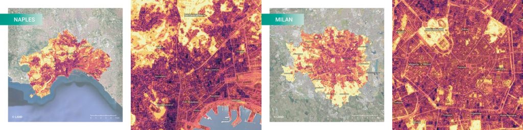
In collaboration with several partners in the field of urban planning and land design, Latitudo 40 delves into leveraging remote sensing and GIS technologies to map out heat risks and propose effective Nature-Based Solutions (NBS) in urban territories. UrbAlytics embodies the synergy between Artificial Intelligence (AI) and Earth Observation technologies, paving the way for groundbreaking tools in urban planning and climate adaptation. A significant hurdle in urban environmental analysis has been the lack of detailed information on vegetation types and tree cover, crucial for evaluating a city’s climate performance. Latitudo 40 rises to this challenge, offering a nuanced understanding of Blue and Green Infrastructures’ roles in cities like Naples and Milan.
Latitudo 40 introduced an automated workflow that harnesses Land Surface Temperature models and Surface Urban Heat Islands data from Copernicus Sentinel 2 images. This approach enables a granular Risk Assessment concerning extreme heat, focusing on the exposure and vulnerability of sensitive demographics and the urban fabric. Furthermore, by interpolating Tree Cover Density and Land Cover models, UrbAlytics creates a comprehensive database of urban vegetation’s microclimatic performance, categorizing Blue and Green Infrastructures based on their cooling potential.
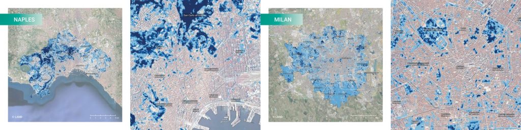
A groundbreaking development by Latitudo 40, the Park Cool Island (PCI) assessment, revolutionizes the understanding of green spaces in mitigating urban heat. This tool, augmented with Surface UHI data, illuminates safe zones during heatwaves, offering crucial data for public health planning and emergency strategies. The PCI layer meticulously categorizes urban parks into Major and Minor Cool Islands based on their cooling impacts. Major PCIs, sprawling across more than 2 hectares with over 50% tree canopy, extend their cooling influence to up to 300 meters. In contrast, Minor PCIs, varying in size and canopy coverage, provide cooling benefits up to 100 meters. This classification system serves multiple purposes, providing essential information for urban planning, real estate, environmental conservation and the healthcare sector.
The overarching goal? To arm local authorities with a robust framework for integrating NBS, fostering urban spaces that are not only climate-resilient but also vibrant, healthy, and biodiverse.
At the heart of this approach stands another tool, the Latitudo 40 Urban Simulator. It is a pioneering tool capable of simulating and evaluating future urban scenarios solely through satellite imagery and Artificial Intelligence. it offers an objective means to compare design and strategic alternatives, thereby facilitating the determination of the most effective urban planning solution. This tool allows for the virtual testing of urban solutions, thus avoiding economically and time-consuming field modifications and tests by measuring the environmental benefits and impact on the examined area. All of this is enhanced by our Super Resolution tool, which fines the resolution of satellite images beyond their native capabilities, providing sharper, more detailed views that are crucial for accurate urban planning and analysis.
In this case study , done at the old NATO base in Bagnoli, Napoli, Latitudo 40 built a series of potential design scenarios that could represent a possible evolution of the area over time. These scenarios included actions such as de-paving, parking removal, and the introduction of tree plantings, showcasing how targeted green interventions can transform urban spaces.
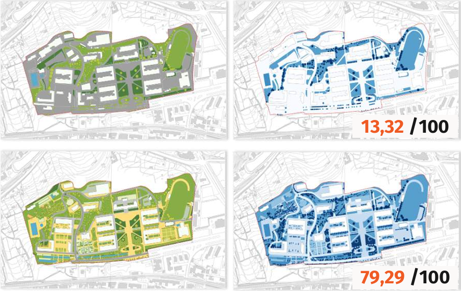
It is evident how, depending on the changes designed on the synthetic satellite image, the territorial fabric can drastically transform, leading to numerous environmental and social benefits. These benefits range from reduced urban heat island effects and improved air quality to enhanced community spaces that promote social interaction and physical activity. Through the meticulous analysis of various design scenarios, it becomes possible to identify which interventions yield the greatest positive impact. In essence, the Urban Simulator acts as a bridge between present urban challenges and visionary solutions, enabling city planners, architects, and policymakers to make data-driven decisions that align with sustainability goals.
In order to develop more capabilities in delivering advanced environmental insights, we have introduced EarthDataPlace, a groundbreaking service designed to streamline access to processed satellite imagery. As the inaugural marketplace devoted entirely to satellite-derived layers, it not only features algorithms created by Latitudo 40 but also welcomes contributions from other firms.
By leveraging the power of AI and satellite imagery, Latitudo 40 is at the forefront of redefining urban landscapes for a more sustainable and vibrant future.
In today’s climate-challenged world, Latitudo 40 stands at the forefront of sustainable urban development, harnessing the power of Artificial Intelligence (AI) and satellite imagery to pioneer innovative solutions. The UrbAlytics project exemplifies this by using advanced geospatial analytics to map heat risks and propose Nature-Based Solutions (NBS) for cities like Naples and Milan. The groundbreaking Urban Simulator, enhanced by Super Resolution technology, allows for the simulation and evaluation of future urban scenarios, offering insights into the environmental and social benefits of urban green interventions. To support the dissemination and commercial development of these advanced environmental insights, Latitudo 40 has launched EarthDataPlace, a novel marketplace dedicated to processed
satellite imagery layers. This initiative is redefining urban landscapes, paving the way for cities that are not just sustainable but thriving in the face of environmental challenges.